AUCKLAND (Pacific Media Watch): If you thought that all parts of the world were chartered in 2013, you were mistaken. In an interesting development, Australian scientists have established that Sandy Island (Île de Sable) never existed after visiting the area where it was supposed to be located October last year.
Earlier this month, researcher Maria Seton of the University of Sydney published an obituary over the island which was reportedly sighted by the French whaling ship Velocity in 1876.
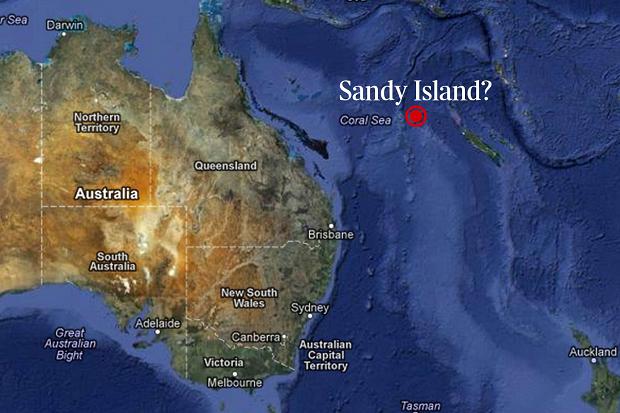
The first recorded map showing the existence of Sandy Island is a British Admiralty chart from 1908. It placed the phantom island approximately 500 km northwest of New Caledonia.
You can read the journal article titled ‘Obituary: Sandy Island (1876 – 2012) published in EOS, the journal of the American Geophysical Union, here.
When the news about Sandy Island’s non-existence first broke in November last year, it quickly became a massive news story. The article Where did it go? Scientists ‘undiscover’ Pacific island was the most read story in the Sydney Morning Herald’s website in 2012.
Appeared in several maps
Maria Seton and other scientists aboard the R/V Surveyor were travelling between two dredge sites when they discovered what she describes as a “quirky discrepancy in maps of seafloor topography”.
As they were passing between Chesterfield Islands and Nereus Reef they were supposed to be at the location of Sandy Island, which was coming up in numerous scientific data sets as well Google Earth.
“The crew looked out over the vast expanse of open ocean where the island was supposed to be. What they saw confirmed what they had suspected: Data sets showing the island were wrong," Seton wrote in her recent journal article.
Seton, who was chief scientist on board the R/V Surveyor, told the Sydney Morning Herald that they became suspicious of Sandy Island’s existence when the boat’s navigation charts showed a depth of 1400 metres in the area.
Removed many times
Sandy Island’s existence was, however, questioned long before it was officially ‘undiscovered’ last year.
Already in 1974, Sandy Island was removed from the official hydrographic charts by the French Hydrographic Service, because it had never been discovered. The same was done by the Australian Hydrographic Service in 1985. Other maps put the abbreviation ‘ED’ – existence doubtful – next to Sandy Island.
According to the old data, the island was supposed to be 20 km long and five km wide, making it slightly larger than Waiheke Island in New Zealand.
Nevertheless, the island’s false existence lived on. According to the Washington Post, Sandy Island was appearing in maps from the US National Geophysical Data Center, earlier this month.
Modern day problem
The digital age might be to blame for why Sandy Island’s existence was not disproven until 2012.
Although it already had officially been excluded in France and Australia, its presence was copied during the conversion from hard-copy to digital maps.
In the digital age with a plethora of map services, Sandy Island’s existence was firmly established in a range of sources. Among them were Google Earth and National Geographic, which both removed Sandy Island from their maps late last year after Seton’s findings became public.
The Washington Post journalist, Joel Achenbach, wrote in his blog that the problem “goes beyond cartographic data: the web is full of information that isn’t true. It’s easily reproduced with cut-and-paste technology.[…] I think the web is particularly good at putting an authoritative gloss on squishy information.”
The upside of new technology, however, is that the information may easily be rectified, and in the weeks after Sandy Island was ‘sunk’ last year several data sets have been updated, according to Seton.
How did it emerge?
After it was discovered that Sandy Island never existed, several researchers have asked themselves why the presence of Sandy Island was recorded in the first place.
Some have suggested that the island might have eroded by waves, like some ephemeral coral atolls. This is impossible, according to Seton, as the sea level in the area is too deep for something to have been there in the late 19th century.
Seton instead suggests the French whaling ship Velocity may have spotted a pumice raft. A recent study found that sea-rafted pumice from a volcano along the Tofua Arc off Tonga, travelled more than 3000 km westward.
Although the sighting may have simply been a navigational error by the Velocity, the size of Sandy Island is consistent with what a pumice raft can be.

This work is licensed under a Creative Commons Attribution-NonCommercial 3.0 New Zealand Licence.


